Address

Amt für Touristik, Kultur und Öffentlichkeitsarbeit
- Citytourism  -
Marktplatz 1 (Altes Rathaus)
69469 Weinheim

tel.: +49 6201 / 82 - 610
fax: +49 6201 / 82 - 619
e-mail

How to reach us:
plan (511 KB)

Opening time:
Wed., Thu.
Fri., Sat,
10 am - 3 pm
10 am - 3 pm
Recommend this page

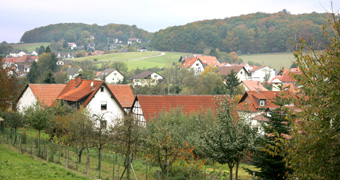
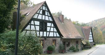
The various districts of Weinheim are located along the Holiday Route Bergstrasse as well as in the Odenwald Forest. Sulzbach to the north, Hohensachsen to the south, and Oberflockenbach, for example, to the east, each incorporated into Weinheim between 1971 and 1973.

Where to Visit in the

City’s Districts

Hohensachsen’s mine "Grube Marie in der Kohlbach"

This historic lead and silver mine lies to the south-east of Hohensachsen above the parking lot for hikers “Am Kohlbach” and shows the history of mining in the area. You can visit the “Grube Marie“ in a guided tour.

Hohensachsen Town Hall

The date 1538 on the stone tablet in the facade refers to the former building that burned down in 1674. Twelve years later, the Town Hall was reconstructed and in the 18th century crowned with a ridge turret.

Hohensachsen Catholic Rectory

The church was constructed in 1772 and fitted with a ridge turret in 1813. The Rectory was established in 1787. The Teutonic Order Cross in the portal lintel refers to the fact that the right of patronage of St. James’ Church was transferred to the Teutonic Order.

Lützelsachsen Evangelical Church

The reformed church, built in 1773, was the first church building in the district. In 1908, a neo-baroque bell tower was attached to the triaxial hall. In 2000 and 2001, the church was renovated and the interior designed in a contemporary style.

Lützelsachsen Historical Town Hall

The two-storeyed timber framing ofthe Renaissance, with its saddle roof and ridge turret was erected in 1688 above the road thoroughfare. Rebuilt in 1808 and refurbished in 2015. Even today the Administrative position Lützelsachsen is located in this building.

Oberflockenbach Atzelhof

The Atzelhof, a half-timbered building from the early 17th century, stands out from the Oberflockenbach landscape with its age and setting. A series of attractive farmsteads mostly dating back to the 18th and 19th centuries are located here.

Rippenweier/Heiligkreuz Hessenmühle (Hessen Mill)

The mill, which was first mentioned in 1545, was destroyed in the Thirty Years’ War. The large half-timbered farmstead with mill building originates from the 18th century and was used intermittently as a paper mill and a copper smelting facility.

Rippenweier/Heiligkreuz Evangelical Church

The Holy Cross Chapel was first mentioned in 1496. The choir and eastern part of the current nave date back to the first half of the 14th century. The tower with pointed spire originates from the 15th century. From 1699 to 1969, the church was used as a cross-denominational church by both denominations.

Ritschweier Wayside Shrine "Am kalten Stein"

The wayside shrine located at the crossroads of the roads from Ritschweier to Oberkunzenbach and from Weinheim to Oberflockenbach originates from the 16th/17th centuries, possibly even from the late Gothic period. It bears the name "Kalter Herrgott" (“Cold Lord”) due to the cold wind that blows over this high plateau.

Sulzbach Town Hall

This two-story house, designed in the classical style in 1836, with its three arcades on the first floor, has housed the local administration authorities of Sulzbach for over 150 years. The coat of arms of Sulzbach, a five-pointed silver star in a blue field, is mounted above the center arc.